|
Greeting from Waco! As we all embrace the changing of seasons (quite gratefully after the epic Winter Storm that rocked Texas), there is new growth and greenery abundant across campus. The members of the McManamay Lab, despite some pollen invasions, are so excited for sunny days and outdoor adventures. In the fields of Environmental Science, we rejoice with nature's glow and are thrilled to seek out new opportunities for discovery and for appreciation of the complex interworking’s in our natural environment. 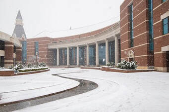 Despite clearer skies and warmer days, there are some members of the McManamay lab who remain indoors, watching their field work counterparts prepare for expeditions. Although still filled with their appreciation for the great outdoors, there are still great and fulfilling things to be done, elbows deep in data analysis and modeling building for PhD student Jillian Sturtevant. Jillian is passionate about the land water energy nexus in the United States. This motivation comes from a deep-rooted love for people and communities and the natural environment.  The work that Jillian is doing in the land use sector is aimed at having a direct impact on city planning in relation to resource allocation and the ways growing urbanization need be considered for a sustainable future. Summarizing Jillian’s work by the simple phrase “land, water, energy nexus” does a disservice to the vast and complex networks in which Jillian has tasks herself with untangling. If data computation and management were a wrestling league, Jillian would be the heavy weight champion. Jillian is not in the megabyte or gigabyte realm, but the terabyte realm of geospatial data storage and processing. 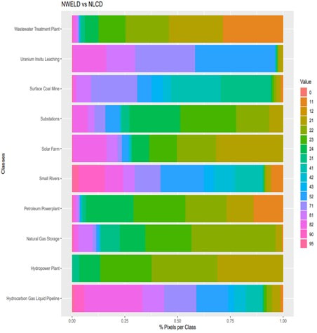 Consolidating vast previous datasets of these networks, proved to be no small feat, as currently published and utilized geospatial databases do not always coincide in accuracy and resolution. Marrying these resources, as well as filling in the remaining gaps with newly generated data from API and Google Maps has resulted in NWELD, the National Water Energy Land Dataset, a composite geodatabase of significant size, and accurate up to a 30 x 30 meter grid resolution of all involved networks within the 95 layers of information. The figure represents how previous land use or land cover data products would classify NWELD layers (for example, where NWELD has identified wastewater treatment plants, NLCD classifies that land as open water and low/medium/high urban development; i.e. NWELD is much more specific compared to previous data products). 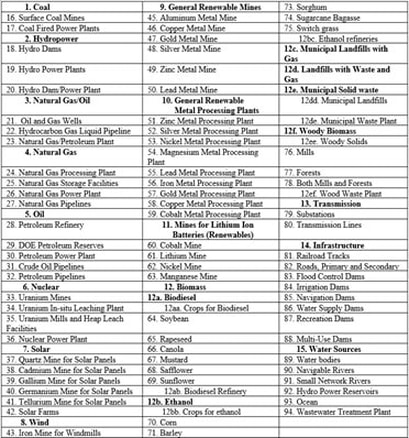 Her process for generating a highly accurate model and geospatial dataset has resulted in a 95 distinct layers that each individually represents some aspect or network within our water and energy systems. The depth and breadth of this dataset is astounding. The hope is that this database will effectively and more accurately provide developers, researchers, policy makers, and city planners with information to move forward in a vastly urbanizing world of limited resources in the United States economy. 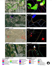 The images examples of the NWELD product with contextual aerial imagery. As you can see, the availability of this accurate and complex geospatial modeling can significantly and measurably impact the way in which developers and researchers understand and interact with the land water energy nexus.
Her work is aimed at “how specifically land use data can aid in protecting the natural environment and biodiversity in urban areas via city planning.” We look forward to seeing Jillian’s work progress and be used for impactful research across disciplines! Keep your eyes on our Publications page for Jillian’s work, and check out her profile on our People page. If you want to network, ask questions, collaborate, or congratulate Jillian on her work, you can reach Jillian or Dr. McManamay at [email protected] and [email protected], respectively. Comments are closed.
|
AuthorSArchives
May 2024
Categories |
 RSS Feed
